National Hurricane Center Tracking 3 Potential Hurricanes
UPDATED August 19 10:37 A.M.: Two potential storms are being tracked in the 5 Day Outlook from the National Hurricane Center, Miami, Florida as of August 18th. Now a third area of disturbance is following them!
Estimates for the number of storms we will see in 2020 have ranged as high as 25. Given the National Hurricane Center is tracking 3 potential storms we could well see more than that, which would mean we would start over on storm names in the same year! (We would run out of alphabet!)
The most storms ever occurred in 2005 with 28 named storms. The least active year was 1914 with just one named storm. National Hurricane Center is now tracking 3 potential hurricanes on very similar paths.
Hurricane Josephine became our 10th named storm and Tropical Storm Kyle became our 11th. Typically we do not see a tenth storm until around mid October. There are now two tropical waves with the first having a 20 to 50% chance of becoming a named storm as it rushes at 20 mph to reach the Caribbean Sea over the next 5 days. NOTE: The first area of disturbance now has an 80% chance of becoming a named storm and is moving Westward at a speed of 15 to 20 mph over the central Caribbean Sea. The disturbance following it has grown to a 90% chance of intensifying to cyclone level in the next 5 days. Following these we now have an area lying over Guinea and Sierra-Leone, Africa that is associated with a vigorous tropical wave according to the NOAA’s National Hurricane Center in Miami.
The second wave is currently located South Southeast of the Cabo Verde Islands and is forecast to move West Northwest over the next few days, which could cause it to mingle with another low pressure system.
If either storm should succeed in forming, it would be the Atlantic basin’s 13th depression and if it spins up to Tropical Storm strength would be our 12th named storm, Tropical Storm Laura.

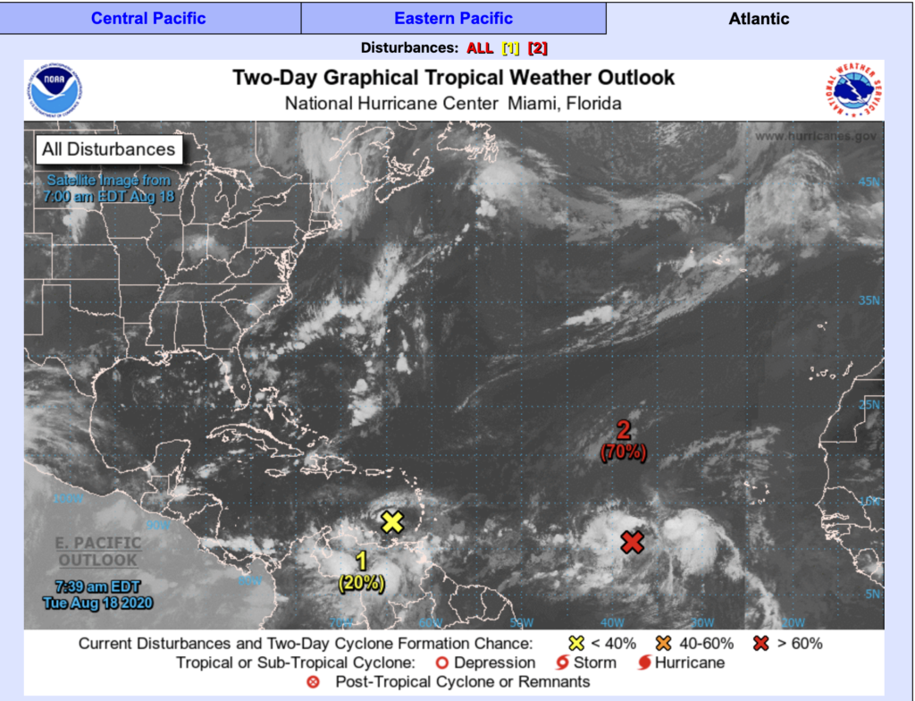
As of today, 08.18.2020 the storms have separated somewhat with the faster moving storm pulling further into the eastern Caribbean and not expected to strengthen over the next two days. However, as it moves westward it is expected to potentially become a depression or tropical storm by the weekend to early next week.
The second area of interest (in red) is in an area that is environmentally conducive to producing a storm. The chances are 70% that it will become a depression or tropical storm within the next 48 hours.

Recent Comments